Five Bridges Bike Tour along the McDade Trail – Southern
Experience biking along the scenic McDade Trail! Enjoy a five-mile ride across beautiful bridges to the
historic Owen’s Natural Spring House. Once there, choose between a ten-mile round-trip or venture further for
breathtaking views of the Delaware River, perfect for all skill levels. Most excursions last two to three hours,
providing ample time to relax and swim in the river afterward.
Join a self-guided bike tour through the Delaware Water Gap National Recreation Area along the 30-mile McDade
Trail, which stretches from the Hialeah Picnic Area to Milford, PA. Discover designated picnic and swimming
spots, complete with restrooms along the route.
In the southern section of the trail, take in stunning mountain views, river panoramas, historical landmarks,
and vibrant wildlife, with remnants of old settlements inviting exploration.
Need a bike? Rentals are provided at the Smithfield Beach trailhead from Action Bikes and Outdoor, which
includes a bike and a helmet. Enjoy amenities such as swimming areas, picnic spots, and restrooms at Smithfield
Beach. Please note that a $10 parking fee applies per vehicle.
Embark on this memorable biking adventure today!
- Bring: Bike or rent a bike, helmet, spare tire, bike tools, bike lock, at least two liters of water, food, a
backpack to store food and water, and bike gloves
- Pack lunch during breakfast.
- Participants will rent bikes directly from Action Bikes
and Outdoor. The listed price is $60 plus tax.
- Private bikes: You must be able to drive your bike to the parking lot for the starting point. $10 per
vehicle for parking (driver keeps receipt for reimbursement)
- 9:45 am ~ 4:30 pm
- Limit: 8 people
- Distance from Camp 61 Miles / 90 Min R/T
- Vehicle: Personal Cars
- McDade Trail Description/Map
- Click HERE for more info
Paddling on the Delaware River
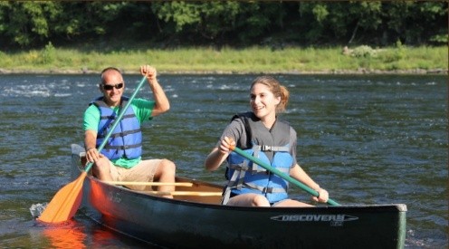 Enjoy a 9.5-mile section of the Delaware River from Barryville to Pond Eddy. This paddle is not for novices, as you will need
to steer in moving water. There is a mixture of ten Class I and Class II rapids along the way. Named rapids
include Cedar Rift (Class II), Owens Rift (Class I), Shohola Rift (Class II), and Mitchie Rift (Class I), along
with a few smaller Class I rapids. Canoes, kayaks, double kayaks, and solo canoes will be available for rent
from Indian Head Canoes. There is a good chance of seeing bald eagles, ospreys,
and occasionally whitetail deer. See the remnants of the Delaware & Hudson Canal and pass by Camp
Tel-Yehudah. This segment of the river is within the Upper Delaware Scenic and Recreational River.
Enjoy a 9.5-mile section of the Delaware River from Barryville to Pond Eddy. This paddle is not for novices, as you will need
to steer in moving water. There is a mixture of ten Class I and Class II rapids along the way. Named rapids
include Cedar Rift (Class II), Owens Rift (Class I), Shohola Rift (Class II), and Mitchie Rift (Class I), along
with a few smaller Class I rapids. Canoes, kayaks, double kayaks, and solo canoes will be available for rent
from Indian Head Canoes. There is a good chance of seeing bald eagles, ospreys,
and occasionally whitetail deer. See the remnants of the Delaware & Hudson Canal and pass by Camp
Tel-Yehudah. This segment of the river is within the Upper Delaware Scenic and Recreational River.
- Bring water, food, sunscreen, dry bags to hold lunch, and closed-toe shoes for water activities.
- Cost $72 (pre-paid per person). Includes rental of boat, paddle, PFD, and transportation
- Approx. 8:30 am ~ 4:30 pm
- Limit 12 People
- Distance from camp 29 Miles | 50 Min R/T
- Vehicle: Personal Cars
- Vendor: Indian Head Canoes
- YouTube
- Click HERE for more info
Wolf, Wine, and Art Tour
Embark on an unforgettable journey at the Lakota Wolf Preserve! Witness the majesty of four thriving wolf packs in
their natural habitat. Experience an exclusive guided presentation that explores their social structure, feeding
behaviors, and unique interactions. Marvel at these magnificent creatures as they play in their wooded homes,
and listen closely for the sound of a wolf's howl.
But the adventure doesn’t stop there! After your wolf encounter, head to Brook Hollow Winery for
an engaging tour that reveals the secrets of winemaking.
Next, immerse yourself in downtown Stroudsburg, where you can enjoy three additional wineries and cideries. Stroll through the vibrant murals and explore captivating art shops that showcase local talent. Connect with nature, wines, and the
creative spirit of Stroudsburg!
Join us for a day of exploration and connection with extraordinary wildlife and local culture!
- Bring Water, a packed lunch for breakfast, and Money to purchase wine.
- Cost $57 per person
- Time: 8:30 am ~ 4:30 pm
- Limit 15 people
- Total Driving time round trip: 2 hr. 15 min (91.7 miles) in three parts
- Vehicle: 15-Passenger Van
- Click HERE for more info
Grey Towers and Milford Town Tour
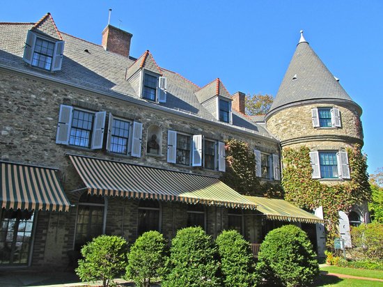 Grey Towers, the ancestral home of Gifford Pinchot—the first chief of the U.S. Forest
Service and a two-time Governor of Pennsylvania—is celebrated as the birthplace of conservation in America. It
now serves as a conservation education center, offering programs highlighting the Pinchot family's legacy.
We'll enjoy a one-hour private tour of the mansion and its grounds, plus some time to explore further and
possibly hike in the woods.
Grey Towers, the ancestral home of Gifford Pinchot—the first chief of the U.S. Forest
Service and a two-time Governor of Pennsylvania—is celebrated as the birthplace of conservation in America. It
now serves as a conservation education center, offering programs highlighting the Pinchot family's legacy.
We'll enjoy a one-hour private tour of the mansion and its grounds, plus some time to explore further and
possibly hike in the woods.
Afterward, we'll head to Milford, PA, where you can shop at local stores or take a self-guided tour of the
historic district dating back to 1733. Milford is the northern gateway to the Delaware Water Gap National
Recreation Area. This significant village is known for its conservation history, with 75% designated National Historic District featuring boutiques, shops, art
galleries, and antiques.
Incorporated on December 25, 1874, Milford's history dates back to 1733 when Tom Quick settled here. The
village layout, designed by John Biddis in 1796, includes streets named after his children. Notable historic
buildings include Forest Hall, Hotel Fauchere,
the Courthouse, Grey Towers, The Columns (which display The Lincoln Flag), the Upper
Mill, Community House, Callahan House, Dimmick Inn, and Tom Quick Inn. Strolling along these tree-lined streets
evokes feelings of peace and nostalgia. A section of Broad and Harford Streets was designated as a National
Historic District in 1999.
Milford is perched on an escarpment above the Delaware River, where waterways create a fluviarchy—an interconnected
series of waterfalls that powered the mills crucial to Milford's 19th-century economy.
Moderate Hike to Stairway to Heaven on the Appalachian Trail
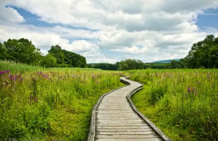 Pochuck Valley to Pinwheel Vista is a gorgeous and diverse section of the Appalachian
Trail through northern NJ.
Pochuck Valley to Pinwheel Vista is a gorgeous and diverse section of the Appalachian
Trail through northern NJ.
Explore the stunning and diverse Appalachian Trail section in northern New Jersey. Hike along boardwalks,
across a suspension bridge, through hardwood forests, past fields of wildflowers, alongside train tracks, near a
cow pasture, and over a boulder field before steeply ascending more than 1,100 feet up the “Stairway to Heaven”
to reach one of the best viewpoints in NJ: Pinwheel Vista. At the top, you can see the Kittatinny Mountains in
the distance, farms in the valley below, and the High Point Monument on clear days. Then, turn around and
retrace your steps.
This is a moderate hike, with the trail surface varying from easy boardwalks to flat, hard-packed areas, dirt,
and some challenging rocky sections. The “Stairway to Heaven” includes rock slab steps with switchbacks leading
up Wawayanda Mountain.
This is a 7.4-mile out-and-back hike. We will proceed at a moderate pace of about 2 miles per hour, slowing
down on the uphill sections with occasional breaks. Hiking shoes or trail runners are required. We may stop at
Heaven Hill Farm for ice cream, depending on the group's time and interest.
- Bring standard hiking gear: hat, food, water, hiking stick, and sturdy hiking shoes
- Pack lunch at breakfast to bring with you
- Cost: $14 Transportation Fee (bring cash with you for ice cream)
- Time: 8:30 am ~ 4:30 pm
- Limit: 15 People
- Distance from camp: 90 Min / 64 Miles R/T
- Vehicle: Passenger Van or Personal Cars (TBD)
- Click HERE for more details
Moderate Shohola Falls and Marsh Reservoir Birding Hike
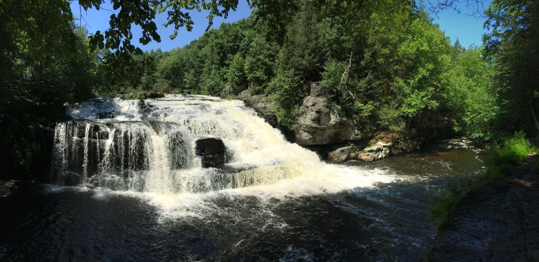 Embark on a captivating hike as we admire Shohola Falls from three unique perspectives. This
magnificent waterfall, spanning seventy-five feet in width and rising fifty feet tall, showcases the
breathtaking power of nature. The constant flow of water cascades dramatically, leaving spectators in awe, even
during drier seasons when neighboring falls may run low.
Embark on a captivating hike as we admire Shohola Falls from three unique perspectives. This
magnificent waterfall, spanning seventy-five feet in width and rising fifty feet tall, showcases the
breathtaking power of nature. The constant flow of water cascades dramatically, leaving spectators in awe, even
during drier seasons when neighboring falls may run low.
Our adventure continues as we explore the diverse landscapes surrounding the Shohola Marsh Reservoir within the
State Game Area. Experience stunning views of the lake and its diverse habitats, which are home to a wide range
of bird species. This engaging eight-mile hike features gentle elevations, totaling less than 500 feet of gain,
making it accessible and enjoyable for all.
Recognized by Audubon Pennsylvania as a vital birding hotspot, Shohola Marsh Reservoir is primarily managed for
waterfowl while supporting numerous other wildlife. Various shorebirds visit the marshy areas and shorelines
each spring and fall, foraging for food during migration. The lush wetlands, thick with alders, sedges, rushes,
and buttonbush, provide essential nourishment and shelter for migrating and nesting birds.
The history of Shohola Creek includes the damming process that formed the lake and flooded low-lying timber
stands. The resulting standing dead trees offer nesting opportunities for various bird species. Cavity-nesting
birds such as the wood duck, hooded merganser, eastern screech owl, northern (yellow-shafted) flicker, and hairy
and downy woodpeckers utilize these trees. Furthermore, great blue herons, green herons, waterfowl, and ospreys
frequently perch on these snags, creating a vibrant scene for nature enthusiasts.
Bushkill Falls Hike
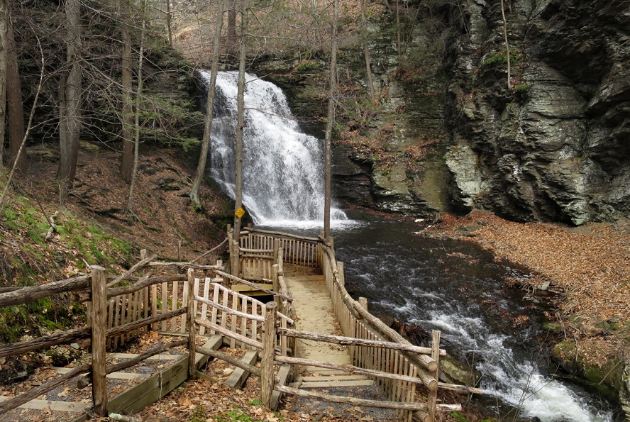 The “Niagara of Pennsylvania,” Bushkill Falls is among the Keystone State’s most
famous scenic attractions. This unique series of eight waterfalls, nestled deep in the wooded Pocono Mountains,
is accessible through an excellent network of hiking trails, walkways, steps, and bridges, which afford fabulous
views of the falls and the surrounding forest. The drop of the Main Falls is approximately one hundred feet. The
drop is about three hundred feet from the top of the first falls to the bottom of the lower gorge. In addition
to the beautiful views of the falls, there are numerous places to marvel at the rock formations and diverse
plant life. Rhododendrons, hemlocks, wild asters, maidenhair ferns, lichen & moss are just a few of
nature's wonders to enjoy. It's not your typical nature walk —it's a sightseeing adventure!
The “Niagara of Pennsylvania,” Bushkill Falls is among the Keystone State’s most
famous scenic attractions. This unique series of eight waterfalls, nestled deep in the wooded Pocono Mountains,
is accessible through an excellent network of hiking trails, walkways, steps, and bridges, which afford fabulous
views of the falls and the surrounding forest. The drop of the Main Falls is approximately one hundred feet. The
drop is about three hundred feet from the top of the first falls to the bottom of the lower gorge. In addition
to the beautiful views of the falls, there are numerous places to marvel at the rock formations and diverse
plant life. Rhododendrons, hemlocks, wild asters, maidenhair ferns, lichen & moss are just a few of
nature's wonders to enjoy. It's not your typical nature walk —it's a sightseeing adventure!
The group will take the two-mile Red Trail (moderate hike), which has a lot of flights of stairs up and down
along the water's edge. Most of the trail (but not all) is decked, and many of the steps are also decked.
You are welcome to take an easier route and then meet the group at the designated time.
Wear sturdy walking or hiking shoes that have good traction on slippery, mossy, rocky areas. Hiking poles are
not recommended. Bring a hat, sunscreen, water, and snacks. Pack lunch at breakfast and $$$ for the gift shop.
Carry all your belongings with you on the trail.
- Please wear sturdy walking/hiking shoes that have good traction for slippery/mossy rocky areas. Hiking poles
are not recommended.
- Pack lunch at breakfast to bring with you
- Bring $$$ for purchases at the gift shop, trading store, and concession stands.
- Cost: $14 Transportation Fee + $20 Entrance Fee + Administration Fees = $38
- Time: 8:30 am ~ 2:00 pm
- Limit 12 People
- Distance from camp: 44 Miles / 70 Min R/T
- Vehicle: Personal Cars or 15 Passenger Van (TBD)
- YouTube: Video 1 / Video
2 | Video 3
- Facebook / Vendor Website
- Vendor Trails / AllTrails of the area
- Click HERE for more details
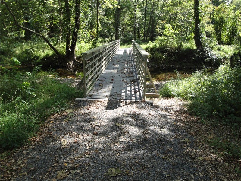
Easy Hike at Cornelia & Florence Bridge Nature Preserve
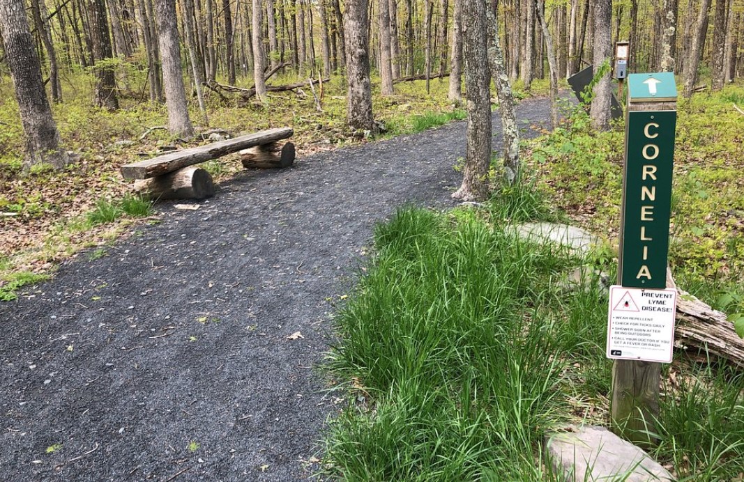 Enjoy a peaceful, leisurely
stroll through the forest near the camp. A significant portion of the three miles of trails in the Preserve are
handicap accessible, featuring gentle hills with a total elevation gain and loss of under 200 ft and primarily
wide, flat paths. However, be cautious in certain areas where rocks and tree roots may pose tripping hazards.
Before his recent passing, Township native Charles Bridge donated his family's 300-acre property to Dingman
Township.
Enjoy a peaceful, leisurely
stroll through the forest near the camp. A significant portion of the three miles of trails in the Preserve are
handicap accessible, featuring gentle hills with a total elevation gain and loss of under 200 ft and primarily
wide, flat paths. However, be cautious in certain areas where rocks and tree roots may pose tripping hazards.
Before his recent passing, Township native Charles Bridge donated his family's 300-acre property to Dingman
Township.
Charlie had two specific visions for the property: to honor his late wife's and mother's dream of
preserving the land and to ensure it remains accessible for public enjoyment. Additionally, he requested that
the park be named the Cornelia and Florence Bridge Preserve in their honor.
- Bring a hat, water, Sneakers, and decent walking shoes. Some areas may become muddy if it has rained
recently.
- Pack lunch at breakfast to bring with you
- Cost: Free
- Time:10:00 am~ 2:00 pm
- Limit: 15 people
- Distance from camp: The hike starts in camp
- Facebook / Website/ Historical Background / Park
Map
- Click HERE for more details