McDade Trail Bike Ride - Northern
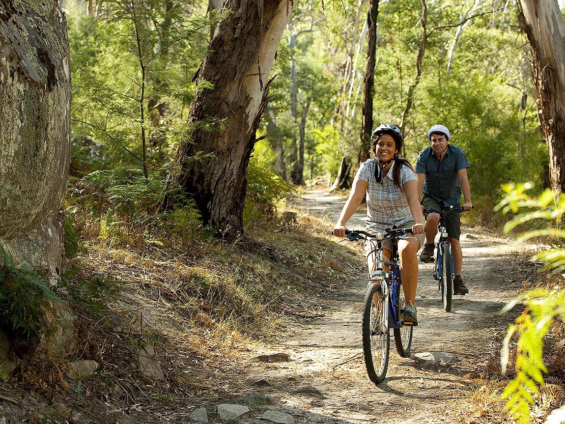 Experience the thrill of biking along the scenic
McDade Trail, starting at the Schneider Farm trailhead. This adventurous out-and-back ride will extend as much
as 10 miles one way, leading you to the tranquil Valley View Group Campground. Along the way, you'll
encounter an overall elevation gain of 76 feet, traversing diverse surfaces of crushed stone and grass. While
the trail offers some ups and downs, rest assured, no single segment boasts a steep gain or loss exceeding 50
feet. Note that the ride south towards the campground generally descends, creating a rewarding challenge for the
return journey. Ideal for those with some mountain biking experience, this trail promises an exhilarating
outdoor experience!
Experience the thrill of biking along the scenic
McDade Trail, starting at the Schneider Farm trailhead. This adventurous out-and-back ride will extend as much
as 10 miles one way, leading you to the tranquil Valley View Group Campground. Along the way, you'll
encounter an overall elevation gain of 76 feet, traversing diverse surfaces of crushed stone and grass. While
the trail offers some ups and downs, rest assured, no single segment boasts a steep gain or loss exceeding 50
feet. Note that the ride south towards the campground generally descends, creating a rewarding challenge for the
return journey. Ideal for those with some mountain biking experience, this trail promises an exhilarating
outdoor experience!
McDade Trail is a 32-mile-long multi-use trail between Milford Beach and Hialeah Trailhead in the Delaware
Water Gap National Recreation Area. The trail offers stunning views of the river, charming streams, expansive
farm fields, lush forests, and historic landscapes. Spotting a Bald Eagle, a Black Bear, a White-Tailed Deer,
and a Wild Turkey is common. The river dominates several miles of the trail to the east and the cliffs to the
west, with the trail and US 209 squeezed between. The McDade Trail features a crushed stone surface, which is
not a flat rail trail but rather an actual bike trail. Hybrids, adventure bikes (such as cyclocross and gravel
bikes), and mountain bikes are ideal for this type of trail. All of our bike ride will be on the secluded bike
path. Rentals are available from Action Bikes and Outdoor.
Anyone bringing a personal bike will drive it to the trailhead. You may be asked to take passengers.
- Bring: Bike or rent a bike, helmet, spare tire, bike tools, bike lock, at least two liters of water, food, a
backpack to store food and water, and bike gloves
- Pack lunch during breakfast.
- Participants will rent bikes directly from Action Bikes
and Outdoor. The listed price is $60 plus tax.
- Private bikes: You must be able to drive your bike to the parking lot for the starting point.
- Cost: 9:45 am ~ 4:30 pm
- Limit: 12 people
- Distance from Camp 28 Miles / 41 Min R/T
- Vehicle: Personal Cars
- TrailForks Map/App
- NYNJTC Delaware Water Gap & Kittatinny Trails Map 2021 - 8th edition Paper / Digital
- Park McDade Trail Description/Map
- Weather Forecasts
- Click HERE for more info
Tubing on the Delaware River - Pond Eddy to Knights Eddy
 Tubing on the crystal-clear Delaware River is the place to be on those hot summer
days. Lay back, relax, and drift along a mild whitewater adventure similar to a lazy river float. Tubing trips
generally last between 3 and 4 hours, depending on river conditions. You will end your float at the
vendor's campground, where you can use the vendor’s bathhouse facilities to clean up, dry off, and change
clothes.
Tubing on the crystal-clear Delaware River is the place to be on those hot summer
days. Lay back, relax, and drift along a mild whitewater adventure similar to a lazy river float. Tubing trips
generally last between 3 and 4 hours, depending on river conditions. You will end your float at the
vendor's campground, where you can use the vendor’s bathhouse facilities to clean up, dry off, and change
clothes.
You will float between Pond Eddy and Knight's Edge down 4 miles of the Upper Delaware Scenic
& Recreational River National Park. This section of the river is known for its scenic views and the
opportunity to experience a variety of river conditions. Note: Some or all parts of your body will be physically
in water for the duration (three to four hours) of your float downriver. You must be comfortable floating in
moving water with or without the assistance of a tube. The ability to swim in moving water is a requirement for
this excursion. You must wear your PFD (personal flotation device) at ALL TIMES while on the water. Anyone
caught without their PFD properly buckled while on the water will be asked to leave the event upon returning to
camp, with no refunds.
- Must wear closed-toe water shoes
- Also wear a swimsuit, hat, and long-sleeved sun shirt (to avoid sunburn), eye retainer like croakies or chums with any glasses
- Bring a paddler’s wallet, sunscreen, a complete change of clothing (including underwear and shoes) for
afterward, and a water bottle that can be tied/clipped (with a large carabiner) to your tube.
- Cost: $59 (pre-paid per person).
- Approx. 9:00 am~ 4:30 pm
- Limit 40 People
- Distance from camp 64 Miles | 43 Min. R/T
- Vehicle: Personal Cars or 15 Passenger Van (TBD)
- Click HERE for more info
Mines, Minerals, and Buckwheat Tour - Sold Out
 Sterling Hill Mining Museum
Embark on a quarter-mile walking adventure into the fourth oldest mine in the country and the last operating
underground mine in New Jersey. Discover the unique fluorescent Rainbow Tunnel, the Museum of Fluorescence, and
the most remarkable collection of fluorescent minerals found anywhere on Earth! Almost everything created by
humans is connected to mining.
You will learn how it is done at the Sterling Hill Mining Museum—from drilling and blasting to processing the
ore. New Jersey is home to one of the world’s richest deposits of zinc ore, featuring over 354 minerals, about
eighty-eight of which fluoresce. That is roughly 10 percent of the known minerals in the world, right here in
NJ, making it the premier fluorescent mineral deposit globally!
The museum is located on the grounds of the Sterling Mine. This former New Jersey Zinc Company mine
successfully operated as New Jersey’s last underground mine until it ceased operations in 1986. The Sterling
Hill Mining Museum is the only place in the state where an underground mine and its associated facilities have
been preserved almost intact and are open to the public.
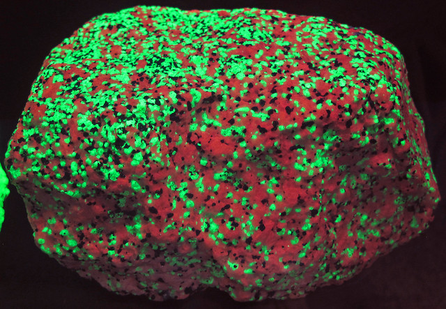 Franklin Mineral Museum
The zinc mining district of Franklin is internationally renowned for its diverse collection of fluorescent and
rare minerals. The museum highlights fluorescent minerals, specimens from local and international sources,
artifacts, fossils, and a two-level mine replica designed with safety in mind. Visitors can explore the famous
"Buckwheat," a sizeable mineral-rich rock field where they can collect specimens, dig for fossils, and
try their hand at gem panning. An optional guided tour will be available during our visit.
-
-
- Both mines maintain a damp temperature of 56 degrees Fahrenheit year-round, so a light jacket is
advisable.
- Proper footwear, such as sturdy hiking shoes, is essential for exploring the “Buckwheat” for
specimens. Collectors must also wear protective eyewear when using tools like hammers and chisels.
- Franklin Mineral Museum does NOT provide specimen-collecting tools; you need to bring your own. Claw
hammers are not allowed.
- Franklin Mineral Museum tour is primarily accessible for wheelchairs and strollers (no wandering in
Buckwheat).
- Pack lunch at breakfast to bring with you
- $14 Transportation Fee (No charge for drivers)
- Participants will pay on site: (please bring cash):
- Limit 12 People
- Vehicle: Passenger Van or Personal Cars (TBD)
- Round Trip Driving: 70 miles / 120 Min in two parts
- Wikipedia of Sterling Mine / Facebook of Stirling
Mine
- YouTube 1
- CLICK HERE for Detailed Information
Lake Wallenpaupack Scenic Boat Tour and Shohola Falls
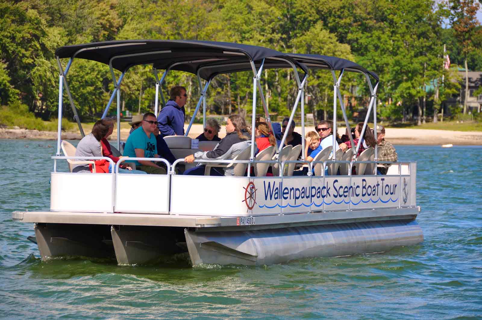 We will start by stopping to view Shohola Falls. This magnificent waterfall, spanning seventy-five feet in
width and rising fifty feet tall, showcases the breathtaking power of nature. The constant flow of water
cascades dramatically, leaving spectators in awe, even during drier seasons when neighboring falls may run low.
We will start by stopping to view Shohola Falls. This magnificent waterfall, spanning seventy-five feet in
width and rising fifty feet tall, showcases the breathtaking power of nature. The constant flow of water
cascades dramatically, leaving spectators in awe, even during drier seasons when neighboring falls may run low.
Afterwards we will experience a breathtaking 50-minute guided tour of Lake Wallenpaupack. During this tour, you
will discover the rich history of this stunning lake region and learn why it has become a popular year-round
destination. Marvel at the Lake Wallenpaupack Hydroelectric Dam, observe local wildlife such as Ospreys, Blue
Herons, and Bald Eagles, learn about the various fish species that inhabit the lake, explore the Shuman Point
Natural Area, and visit Epply Island, one of the four islands on the lake. The tour is led by a fully qualified
captain/tour guide and includes life jackets for your safety.
Lake Wallenpaupack
is a freshwater lake located in northeastern Pennsylvania. It is the third-largest lake in the state,
boasting fifty-two miles of shoreline, an impressive length of thirteen miles, and depths up to sixty feet.
Established in 1926 by the Pennsylvania Power & Light Company (PP&L) for hydroelectric power and flood
control, it is now recognized as a premier recreational destination in the Pocono Mountains. Please note that
the Scenic Boat Tour will cover approximately one-third of the lake during the scheduled time.
- Bring a sweater in case of a chill on the water, water, snack
- Pack lunch at breakfast to bring with you
- Cost: $41/ $39 Seniors (62+)
- Costs include vendor fees, tax, 10% tip, $18 transportation fee, 10% MOCA administration, and
registration fee.
- Time: 9:15 am ~ 1:00 pm
- Limit: 15 People
- Round Trip Driving: 38 Miles / 47 Min
- Vehicle: Passenger Van or Personal Cars (TBD)
- YouTube of the boat tour /Western Viewing of Shohola Falls Trails / Description of Shohola Falls
- Click HERE for more info
Fluviarchy Tour (Easy hiking)
Discover three delightful, easy hikes that showcase six breathtaking waterfalls! Milford offers a unique
experience for nature lovers and outdoor enthusiasts. It is situated atop an escarpment with breathtaking views
of the Delaware River. This remarkable location features a distinctive element known as a "fluviarchy,” a
spectacular network of waterfalls fed by streams cascading down a 100-foot (30 m) elevation. These stunning
falls enhanced the area’s natural beauty and played a vital role in Milford's economy during the nineteenth
century by providing waterpower for local mills. Discover Milford, where nature meets history, and the community
thrives!
George W. Childs Park
First up on our adventure is George W. Childs Park Trail! This scenic trek follows the enchanting Dingmans
Creek through a lush ravine with breathtaking waterfalls and historic structures. Our short hike passes three
stunning waterfalls: the 30-foot Deer Leap Falls, the 56-foot Fulmer Falls, and the unique three-tiered Factory
Falls at 18 feet, all within a shady ravine. Experience nature on our 1.4-mile trail with a minimal elevation
gain of 180 feet. Whether you prefer strolls on smooth paths, boardwalks, or exploring gravel trails, there is
something for everyone. Discover remnants of an old woolen mill from 1823 to 1832, offering a fascinating
glimpse into the area’s history. This site is named after George W. Childs, a philanthropist whose widow deeded
the land to Pennsylvania in 1912. Immerse yourself in nature and history at this stunning park!
Lower Hornbecks Creek Trail
The Hornbecks Creek Trail, also known as Indian Ladders, is a hidden gem in the Delaware Water Gap National
Recreation Area. This trail follows an old roadbed alongside Hornbecks Creek, leading to a charming waterfall
framed by symmetrical cliffs and a round plunge pool. As you hike, enjoy the picturesque flow of the creek,
which is always nearby. The trail offers a gradual ascent and is primarily easy, with short, steep hills. It
starts flat and remains close to the creek, featuring a wide, smooth path free of rocks and roots. You will
cross several footbridges as the trail meanders.
Raymondskill Falls
Raymondskill Falls, at 150 feet (46 meters), is often deemed Pennsylvania's tallest waterfall, though some
argue it shares this title with nearby Dingmans Falls, which has a single drop of 130 feet. The stunning
three-tiered cascade flows into a forest ravine. A short, family-friendly hike leads to overlooks offering views
of the falls' power and beauty. Ideal for hikers, photographers, and nature lovers, Raymondskill Falls is
an unforgettable escape. The trail, starting at the parking area, combines packed dirt, wooden steps, and
boardwalks through a tranquil hardwood forest. This 6/10 Mile (1km) hike has a 200-foot (61-meter) elevation
gain, with the steepest section leading to the upper platform. After a brief downhill walk, you’ll find a wooden
viewing platform at the base (Viewpoint of Lower Falls) offering an impressive view of the cascading tiers.
Continuing up steps, take the right fork to the elevated platform for a dramatic view of the water plunging into
the gorge at the Upper Falls Overlook.
- Bring a hat, food, water, a hiking stick, sturdy shoes, and water shoes for wading.
- Pack lunch at breakfast to bring with you
- Maps: NYNJTC Delaware Water Gap & Kittatinny Trails Map 2021 - 8th edition Paper / Digital
- Cost: $14 Transportation Fee (bring cash with you for ice cream)
- Time: 8:30 am ~ 4:30 pm
- Limit: 15 People
- Round Trip Driving: 34.5 miles / 56 min broken up into five parts.
- Vehicle: 15 Passenger Van
- Click HERE for more details.
Moderate/Strenuous 9 or 6-mile Loop Hike at Highpoint State Park
Experience a refreshing 9 or 6-mile loop hike with approximately seven hundred feet of elevation gain along the
stunning Appalachian and Iris Trails at High Point State Park, near Montague Township, New Jersey. This
invigorating trail features rocky ridges that provide breathtaking views of the surrounding mountains, lush
valleys, picturesque fields, and serene lakes – a perfect escape into nature! The Appalachian and Iris Trails
crisscross each other several times, making a figure eight. You can do the entire 9-mile (980 ft Elevation gain)
figure eight or just the 6-mile (700 ft elevation gain) option, which loops back when the two trails meet the
first time. The group will decide which option to take during Meet Your Leader the night before.
- Bring Standard Hiking Gear: Hat, Water, Food, Walking Stick and Hiking Shoes
- Pack lunch at breakfast to bring with you
- Maps: NYNJTC Delaware Water Gap & Kittatinny Trails Map 2021 - 8th edition Paper / Digital
- Cost: $14 Transportation Fee (Drivers free)
- Time: 9:00 am ~ 4:30 pm
- Limit 15 People
- Cost $14 Transportation Fee (Drivers with passengers are free)
- Round Trip Driving: 38 Miles / 62 Min
- Vehicle: 15 Passenger Van
- AllTrails / NJHiking
- YouTube
- Click HERE for more info
Moderate 4.5 Mile Ridgeline Trail and Upper Indian Ladder Falls Hike at PEEC
- Sold Out
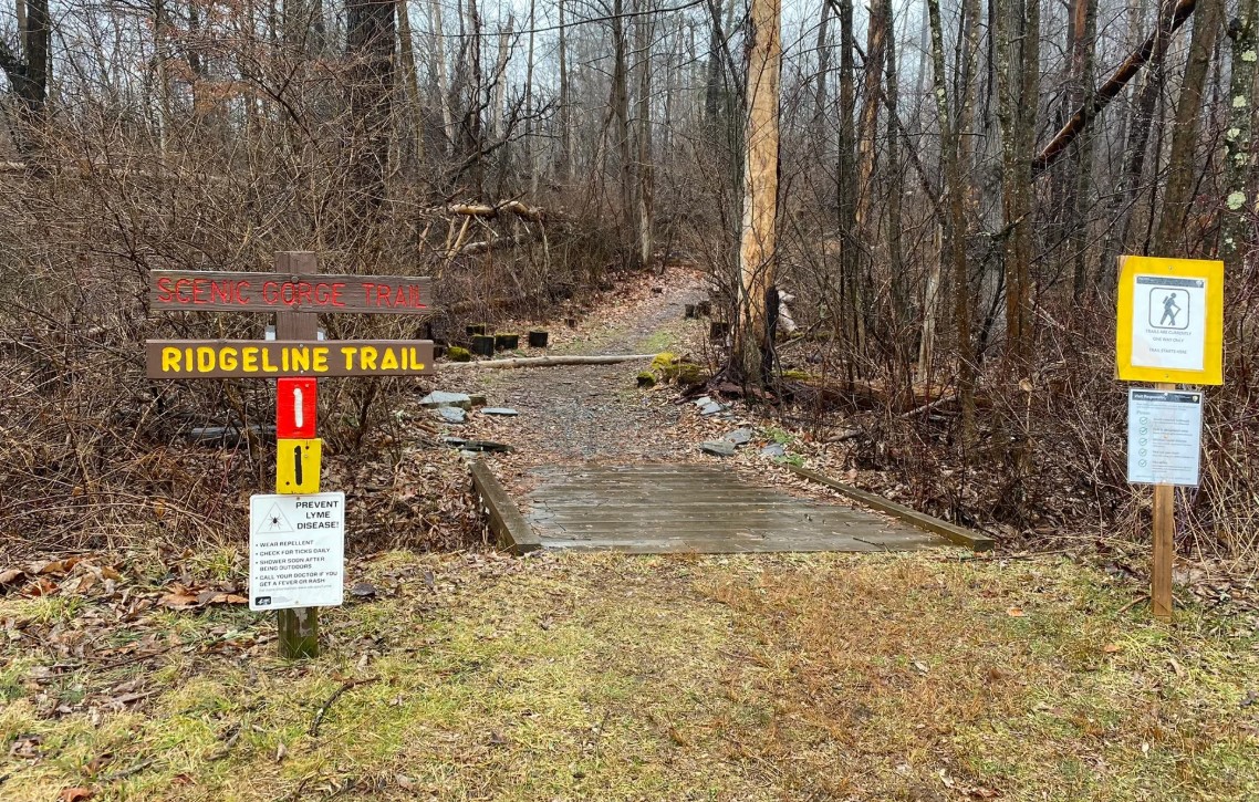
This moderate 4.5-mile trail with over 570 ft elevation gain of several ups and downs, marked with yellow
blazes, features oak-hickory forests, ravines, and wetlands that lead into a mature hemlock forest along
Spackman’s Creek. The Ridgeline Trail coincides with the Scenic Gorge Trail for the first and last half miles.
Remnants of rock walls indicate that this area was once farmland. You will climb ridges and descend steeply
using a rope to reach the gorge while exploring the remains of a cabin and an abandoned dam. The path meanders
through wetlands and leads to a 15-foot waterfall on Alicia Creek before returning alongside the stream to the
start. Additionally, we will visit Upper Indian Ladders Falls, a 30-foot multi-tiered waterfall along Upper
Hornbeck’s Creek.
- This hike repeats on Sunday.
- Bring standard hiking gear: Hat, Walking Stick, Water, Food, Hiking Shoes
- Pack your lunch during breakfast.
- Cost: $14 Transportation Fee (bring cash with you to the gift shop)
- Time: 8:30 am -2:30 pm
- Limit: 15 People
- Distance from camp: 15 Miles /25 Min one-way
- Vehicle: Personal Cars or 15 Passenger Van (TBD)
- Length: 4.5 miles, loop
- Difficulty: Moderate
- Blaze: Yellow
- Elevation Change: 220 feet with 570 feet gain overall with all the ups and downs.
- YouTube1
YouTube2
- Click HERE for more details
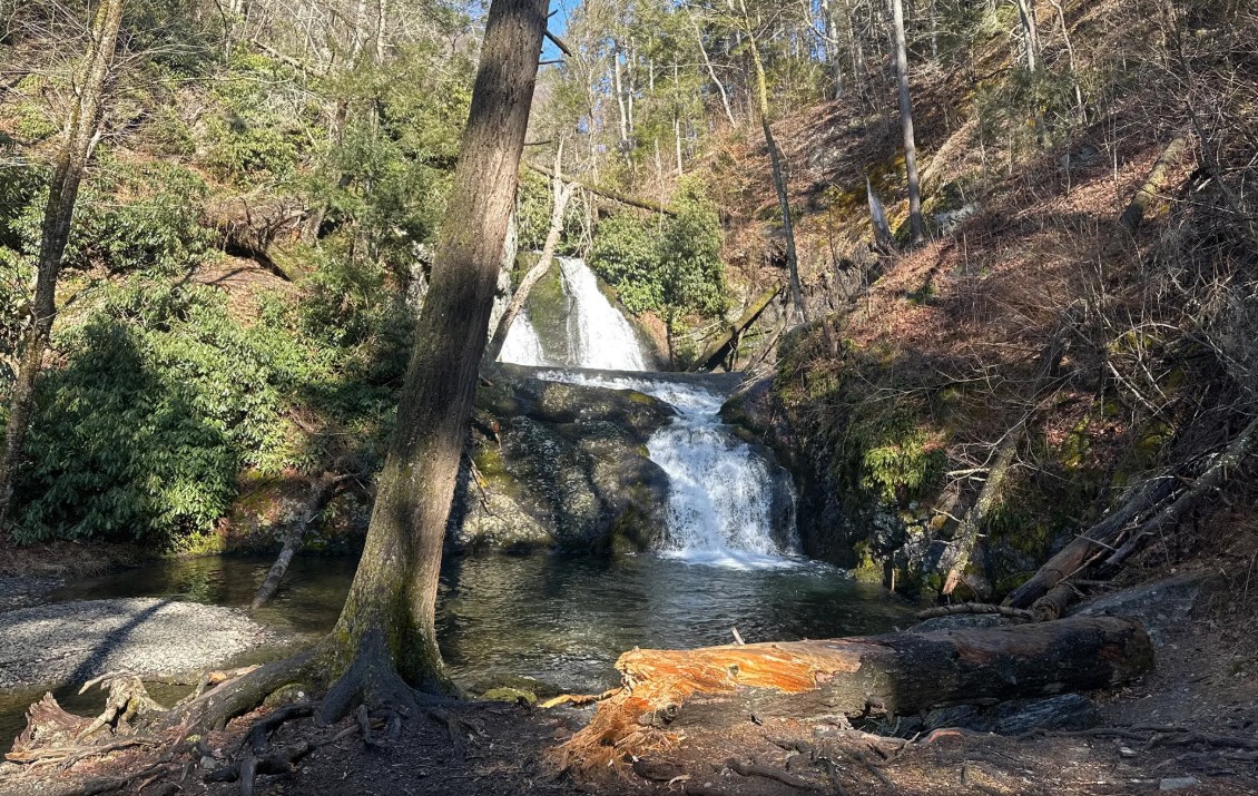
Moderate Hiking at PEEC: 3.8-Mile Tumbling Waters Trail and 1.5-Mile Scenic Gorge Trail
 Discover the breathtaking beauty of Tumbling Waters
Trail, a captivating 3.8-mile hike that winds alongside serene creeks and through lush hemlock ravines. This
moderately challenging trail, marked with vibrant orange blazes, begins at Fossil Trail, conveniently located
just thirty yards from the Pocono Environmental Education Center’s dining hall, directly across from the group
lodges.
Discover the breathtaking beauty of Tumbling Waters
Trail, a captivating 3.8-mile hike that winds alongside serene creeks and through lush hemlock ravines. This
moderately challenging trail, marked with vibrant orange blazes, begins at Fossil Trail, conveniently located
just thirty yards from the Pocono Environmental Education Center’s dining hall, directly across from the group
lodges.
Start your adventure and, after a mile, be rewarded with stunning vistas from Hermits Hill, where mesmerizing
views of the Delaware Valley and Kittatinny Mountains await. Experience the rich diversity of nature along the
path, which meanders through majestic oak and hickory forests, as well as hemlock ravines showcasing remnants of
historic farms.
Venture down a series of switchbacks at 1.5 miles, where wooden stairs lead you 240 feet down to a picturesque
waterfall—a perfect spot to pause for lunch and enjoy the tranquil sounds of nature. After rejuvenating, tackle
the ascent back to the main trail, summiting Killer Hill with an elevation gain of 340 feet from the falls to
the peak. Encounter a variety of landscapes, including a beautiful hemlock forest, a mixed oak forest, and a
peaceful pine plantation, which leads you to Pickerel Pond, just minutes from the trail’s end.
After a well-deserved break at the main lodge for restrooms, continue your journey with an additional hour of
hiking on the easy-to-moderate 1.5-mile Scenic Gorge, starting with the welcoming Ridgeline Trail. Immerse
yourself in the stunning open hardwood forest ecosystem, contrasting with the cool, dark canopy of hemlocks
beside Spackman's Creek.
You can extend your outdoor adventure by exploring the engaging displays at the PEEC grounds, located right in
the main lodge, making for an unforgettable visit.
- This hike repeats on Sunday.
- Bring standard hiking gear: Hat, Walking Stick, Water, Food, Hiking Shoes
- Pack lunch at breakfast to bring with you
- Cost: $14 Transportation Fee (bring cash with you to the gift shop)
- Time: 8:30 am ~ 2:30 pm
- Limit: 15 People
- Vehicle: 15 Passenger Van
- Distance from camp: 15 Miles /25 Min one-way
- Video of Tumbling
Waterfall / Video of
Hike 1 / Video
of Hike 2
- Pictures of the trail
- Click HERE for more details
Moderate Lenape Ridge/Minisink Trail Loop Hike (afternoon)
Discover the beauty of nature with this easy-moderate loop hike along the captivating Lenape Ridge in
Huckleberry Ridge State Forest. Experience diverse vegetation and breathtaking panoramic views, including the
serene Heinlein Pond, the majestic Shawangunk Ridge in NY, and High Point in NJ and beyond.
This four-mile trail offers a straightforward, narrow path that meanders through lush rhododendrons and stately
hemlock forests. Enjoy a stroll along this ridge walk, where you will experience minimal elevation changes once
on the ridgelines, making it perfect for hikers of all levels. With approximately 630+ feet of overall elevation
gain, it is an ideal outing for nature enthusiasts and casual hikers seeking a refreshing adventure in the great
outdoors!
- Bring standard hiking gear: Food, Water, Hiking Shoes, Walking Stick, Hat
- Pack lunch at breakfast to bring with you
- Maps: NYNJTC Delaware Water Gap & Kittatinny Trails Map 2021 - 8th edition Paper / Digital
- Cost: $14 Transportation Fee (Drivers free)
- Time: 12:30 pm ~ 4:30 pm
- Limit: 12 People
- Vehicle: Passenger Van or Personal Cars (TBD):
- Round Trip Driving: 56 Miles / 64 Min
- Click HERE for information
Easy Hike at Cornelia & Florence Bridge Nature Preserve
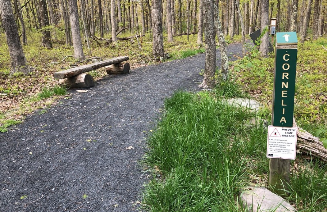
Enjoy a peaceful, leisurely stroll through the forest near the camp. A significant portion of the three miles
of trails in the Preserve are handicap accessible, featuring gentle hills with a total elevation gain and loss
of under 200 ft and primarily wide, flat paths. However, be cautious in certain areas where rocks and tree roots
may pose tripping hazards. Before his recent passing, Township native Charles Bridge donated his family's
300-acre property to Dingman Township.
Charlie had two specific visions for the property: to honor his late wife's and mother's dream of
preserving the land and to ensure it remains accessible for public enjoyment. Additionally, he requested that
the park be named the Cornelia and Florence Bridge Preserve in their honor.
- Bring a hat, water, Sneakers, and decent walking shoes. Some spots might get muddy if it rained
recently.
- Time:1:00 pm~ 4:30 pm
- Limit: 15 people
- Distance from camp: The hike starts in camp
- Facebook / Website/ Historical Background / Park
Map
- Click HERE for more details
Back to the top of the page